TheTrams.co.uk - trams and light rail in the UK
The section of line in the city centre (Victoria/Piccadilly–G-Mex) is described in the City page; G-Mex–Cornbrook is covered in the Altrincham line page.
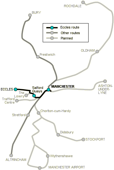
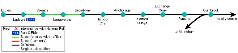
Metrolink's first extension, known as Phase Two, consisted of the Eccles line. The first section to open, in December 1999, was from a new transfer stop at Cornbrook, through the Salford Docks area to Broadway. The remaining section of line, running on-street to the Eccles terminus, opened in July 2000. The line uses a mix of new reserved formation and street-running from junction with the Altrincham line at Cornbrook.
[select a stop for more information]
Cornbrook–Pomona


Cornbrook stop opened with the first stage of the Eccles line. There is no access to the stop from the street—Cornbrook is a transfer stop for people changing between Altrincham line and Eccles line trams. A street entrance is planned, however.
South of Cornbrook there is a grade-seperated junction, with the Altrincham line continuing south west, and Eccles trams diverging towards the west. The Eccles line here runs alongside the Bridgwater Canal, and after crossing it the line runs on a strip of land between this canal and the Manchester Ship Canal, next to the site of Pomona docks. There is an elevated stop at Pomona, potentially the junction for a further extension to Trafford Park and the Trafford Centre.
Manchester Ship Canal
The history of the area served by the Eccles line is bound up with that of the Manchester Ship Canal, a remarkable feat of engineering which allowed ships to reach Salford and Manchester, 35 miles inland from the coast.
The Ship Canal opened in 1894, between Eastham on the River Mersey (near Liverpool) and Manchester, a reaction to exhorbitant handling charges imposed by the Port of Liverpool which were harming industry further inland. Along with various wharves and berths between Liverpool and Manchester, were the Manchester Docks. These consisted of Docks No. 1–4 (Pomona Docks—on the south bank) and Docks No. 5–9 (Salford Docks—on the north bank). During the period when the Manchester Docks were open, the city had its own shipping line—Manchester Liners—remarkable for an inland city.
The canal still sees plenty of shipping traffic, mostly at its Liverpool end but with some ships still coming upstream as far as Trafford Park and even the dry docks just short of Salford Quays. The docks, however, closed in the early 1980s, and after a period of derelection the former Salford Docks area (now referred to as Salford Quays) began the process of renewal and redevelopment familiar in the Docklands of other maritime cities such as London and Liverpool. The former docks are now home to residential and commercial developments, and are unrecognisable as working waterways.
On the opposite bank of the canal is the huge Trafford Park industrial complex—once criss-crossed by the Manchester Ship Canal Railway this area may soon be served by Metrolink trams on their way to the Trafford Centre shopping complex.
Pomona–Broadway


On leaving Pomona stop, the tramway veers right to cross the Manchester Ship Canal, before dropping down to street level once more. From here to Broadway trams run on reserved right of way, but the tracks are not segregated from foot traffic, particularly in the area of Salford Quays stop. There are stops at Exchange Quay (alongside Trafford Road, the main road crossing the Ship Canal between Salford and Trafford Park), Salford Quays (at the top of one of the Salford Docks, next to restaurants and pubs) and Anchorage (surrounded by office development).


Lawn track (track set in grass—actually concrete formers designed to cultivate grass) is used from Anchorage through the staggered platforms at Harbour City to Broadway. Just before Broadway allowance has been made for a possible future ¼-mile spur to The Lowry, a modern arts and entertainment complex.
Broadway–Eccles


On leaving Broadway, trams join South Langworthy Road, which they share with other traffic, to its junction with Eccles New Road. The line turns left onto Eccles New Road, with a stop at Langworthy. The area served by the trams from here to Eccles is a mix of more established housing and light industrial. Metrolink continues along Eccles New Road, with a stop at Weaste next to the former Salford City Transport tram shed, to Ladywell. This is the site of Metrolink's only advertised Park & Ride facility, with a supervised car park. This is advertised as convenient for visitors to The Lowry (tram to Broadway) and Manchester United's Old Trafford football ground (tram to Exchange Quay).


After Ladywell there is an underpass to the the tramway underneath Ladywell Roundabout. As the tram climbs up to Eccles the track singles, and trams terminate at a platform in the centre of the town next to the bus station.
[copyright statement] [terms & conditions] [trespass & safety policy] [privacy]
TheTrams.co.uk is not associated with any transport operator or authority
All content © Peter Courtenay 2004–2024 except where otherwise stated


Page generated in ≈ 0.0043 seconds