Croydon Tramlink : Tram Stops : Waddon Marsh
| Line | Location | Opening date | number of platforms |
|---|---|---|---|
| Wimbledon | reserved track | 30th May 2000 | 2 |
Waddon March replaced a railway station of the same name, which was slightly to the west of the current tram stop. The area served is mostly industrial and retail.
The location of the stop shown on Multimap is incorrect; click on the Multimap links further down the page and the red circle shows the correct position of the stop.
There is more information and photos of Waddon Marsh railway station, including pictures taken between closure and Tramlink construction work, at Subterreanea Britannica's Disused Stations site.
Pictures
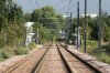
Long shot of Waddon Marsh, looking in the Croydon direction, taken from the site of the former railway station
21/08/2005 • 002161
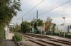
Overall view of Waddon Marsh tram stop, looking towards Croydon
21/08/2005 • 002162
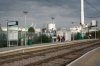
Croydon platform at Waddon Marsh
21/08/2005 • 002163
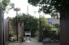
The somewhat uninviting approach to Waddon Marsh stop from Miller Road; the stop is to the left, a short walk along a footpath alongside the tram tracks. This was the entrance to the former Waddon Marsh railway station
21/08/2005 • 002164
Search for more pictures taken at Waddon Marsh
Location
Street map
System map
More map links
- Maps of Waddon Marsh stop on Streetmap:
- View maps or satellite imagery at Google Maps
-
Download a Google Earth KML file
Open in Google Earth or download and install Google Earth Pro
Services and diagram
Services from this stop:
[copyright statement] [terms & conditions] [trespass & safety policy] [privacy]
TheTrams.co.uk is not associated with any transport operator or authority
All content © Peter Courtenay 2004–2026 except where otherwise stated


Page generated in ≈ 0.0213 seconds