TheTrams.co.uk - trams and light rail in the UK
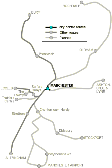
The major part of the Metrolink construction project was linking the two railway lines (Manchester–Bury and Manchester–Altrincham) across the city centre. The Bury line terminated at Manchester Victoria main line station, while Altrincham line trains ran along the southern edge of the city centre from Deansgate through Oxford Road to Manchester Piccadilly and beyond.
Tram lines were laid from Victoria and G-Mex to a delta junction at Piccadilly Gardens, and from there to a terminus at Piccadilly main line railway station. Trams from Bury and Altrincham alternate between terminating at Piccadilly and cross-city services.
[select a stop for pictures]
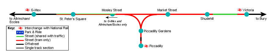
G-Mex–Piccadilly Gardens


G-Mex stop is on a viaduct, on the former Manchester Central (now the G-Mex centre) station throat. It is the changeover point between street-running mode and segregated running mode. Trams towards the city cross Trafford Street and Great Bridgewater Street by new bridges, and then ramp down to Lower Mosely Street at the front of the former Manchester Central station.


The line runs alongside the Midland Hotel, across Peter Street in St. Peter's Square, where there is a tram stop next to Central Library and the Town Hall extension. From here the line runs down Mosley Street, sharing the road with buses in the city-bound direction only, to the Piccadilly Gardens delta junction. Just before the junction there is a single platform (Mosley Street stop), for trams towards G-Mex and Altrincham/Eccles.
Piccadilly Gardens and Piccadilly


The delta junction at Piccadilly Gardens is the busiest part of the Metrolink system—there are 36 tram movements per hour through a very busy pedestrianised area; one arm of the delta cuts across the road entrance to Piccadilly bus station.


Coming from G-Mex, direct trams travel straight across the junction towards Victoria and Bury; trams terminating in the city turn right into Piccadilly Gardens tram stop. From here the line crosses Portland Street, runs down Aytoun Street, across an open space on reserved track, alongside and across London Road, and terminates at Piccadilly (originally named Piccadilly Undercroft), where the tram stop is at street level in the structure of the station, underneath the platforms (the undercroft).


The two platforms at Piccadilly are for arrivals and departures, with trams running empty into reversing sidings which are designed to form part of a future extension to Droylsden and Ashton-under-Lyne.
Piccadilly Gardens–Victoria


After the delta junction, Bury-bound trams turn into Market Street, where there is a tram stop. No vehicular traffic is allowed along Market Street, but trams are not segregated from foot traffic, and during shopping hours the line through the tram stop and at the junction with High Street is overrun with pedestrians. The line runs alongside High Street to a stop on Shudehill which opened in 2003, next to a new transport interchange currently under construction. Trams then run along Baloon Street, crossing Corporation Street before entering Victoria main line station.
[copyright statement] [terms & conditions] [trespass & safety policy] [privacy]
TheTrams.co.uk is not associated with any transport operator or authority
All content © Peter Courtenay 2004–2025 except where otherwise stated


Page generated in ≈ 0.0075 seconds