TheTrams.co.uk - trams and light rail in the UK
Midland Metro : Routes : line one
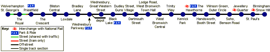
The first line of the Midland Metro tram system runs from Birmingham Snow Hill north west to Wolverhampton, a distance of just over 12½ miles.
Most of the route uses the alignment of the former Great Western Railway Snow Hill–Wolverhampton Low Level line, sharing it most of the way to West Bromwich with the present-day Snow Hill–Stourbridge main line railway route. The alignment is wide enough for four tracks as far as West Bromwich, with the tramway using two tracks and the rest of the alignment given over to main line railway or, through West Bromwich, a public footpath. The final section into Wolverhampton involves a little over a mile of street running along the A41 Bilston Road, most of which is shared with other traffic.
[select a station for pictures]
For a track map, see the LRTA website.
Snow Hill–Jewellery Quarter


Birmingham, Snow Hill stop is part of the much larger Snow Hill main line railway station, occupying space at the city end of the station. On leaving the platforms the tramway narrows to single track and leaves the station alongside what was platform 4. At the end of the main line station platforms the line is restored to double track, running alongside the Snow Hill–Stourbridge railway to Hockley. There is a stop at St. Paul's before the tram and railway tracks enter Hockley Nos. 1 and 2 tunnels. The original construction of the railway route to Brunel's broad guage is evident here, with generous tunnels carrying the tracks under Hockley to Jewellery Quarter where trams and trains share a station.
Jewellery Quarter–The Hawthorns


After leaving Jewellery Quarter the tramway continues to share the railway alignment, with stops at Soho, Benson Road, Winson Green, Outer Circle and Handsworth, Booth Street. Between Winson Green and Handsworth the line rises sharply to climb over a viaduct which crosses some railway sidings—the current A–Z map of Birmingham incorrectly marks this as the site of Midland Metro's depot. The railway and tramway share another station at The Hawthorns, then the railway tracks veer left (south west) towards Smethwick, and the tramway continues alone towards West Bromwich.
West Bromwich


After The Hawthorns the tramway runs alongside the West Bromwich Parkway, the footpath which, until the opening of the Midland Metro, had exlusive use of the former railway trackbed.


There are six stops in the West Bromwich area—Kenrick Park, Trinity Way, West Bromwich Central (on the site of the former railway station), Lodge Road, West Bromwich Town Hall, Dartmouth Street and Guns Village. The line runs in a shallow cutting for most of this stretch.
Guns Village–Wednesbury


As the line leaves the West Bromwich area there is a stop at Black Lake, near the site of the former Swan Village railway station. The line then enters a deep cutting before reaching one of the only notable feats of engineering on the line, the short Hill Top Tunnel. On the other side of the tunnel the surroundings change from greenery and residential areas to an inustrial landscape.


As the line enters Wednesbury it crosses the dead-straight Tame Valley Canal and the disused Walsall–Dudley–Stourbridge railway line (earmarked for a possible extension of the Midland Metro south west to Dudley), and comes to Wednesbury, Great Western Street. Here the stop is next to Midland Metro's depot, known as the Metro Centre. The next stop, Wednesbury Parkway, is also within sight of the depot, and it is here that the track to the depot joins the running lines.There follows a long stretch between stops to Bradley Lane.
Bilston


Through Bilston the line is once again surrounded by greenery. After Bradley Lane there are stops at Loxdale, Bilston Central and The Crescent. The line runs in a short section brick-lined cutting, a relic of the line's railway heritage, through Bilston Central station. After The Crescent the tramway reaches the final stop on the railway alignment, at Priestfield, then climbs up to the level of the road, the A41, and turns left (north west) along it to reach Wolverhampton.
Wolverhampton


Midland Metro's only section of street running is in Wolverhampton. From Priestfield to the terminus at Wolverhampton St. Georges, the tramway runs on-street, along the A41 Bilston Road. The trams share the road with other traffic as far as the stop at The Royal.


From here the tramway runs on a reserved right of way along the central reservation of the dual carriageway to the Bilston Street roundabout, and crosses the sunken pedestrian area in the middle of the island on the impressive Wishbone Bridge. On the other side of the island the trams reagin the road, and shortly afterwards is the line's terminus, at Wolverhampton, St. Georges.
[copyright statement] [terms & conditions] [trespass & safety policy] [privacy]
TheTrams.co.uk is not associated with any transport operator or authority
All content © Peter Courtenay 2004–2026 except where otherwise stated


Page generated in ≈ 0.0033 seconds