Tyne and Wear Metro : Routes : Tyne and Wear Metro routes
The initial Metro system, opened in stages from 1980 to 1984, was formed of three converted railway lines, linked across the city centre by two tube tunnels. Since opening, the original network has been supplemented by two extensions—from the original north western terminus at Bank Foot to a new station at Newcastle Airport (opened 1991), and from Pelaw on the South Shields route along Network Rail tracks to Sunderland (opened 2002).
Present network
The present Metro system consists of lines to Newcastle Airport, South Shields, Sunderland and a loop from the city centre to the North Tyneside coast and back. The routes from Airport, South Shields, and Sunderland, and one end of the North Tyneside Loop, converge on a central section through Newcastle city centre, between Gosforth and Pelaw stations. The other end of the Tyne Coast loop runs into the city centre to terminate at St. James, crossing the Pelaw–Gosforth route very roughly at right angles, with an interchange at Monument: thus trains from St. James to South Shields call at Monument twice, using a different plaform each time.
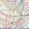
Click for a map of the Tyne and Wear Metro in Newcastle city centre.
[copyright statement] [terms & conditions] [trespass & safety policy] [privacy]
TheTrams.co.uk is not associated with any transport operator or authority
All content © Peter Courtenay 2004–2026 except where otherwise stated


Page generated in ≈ 0.0071 seconds