Croydon Tramlink : Routes : New Addington
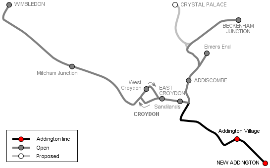
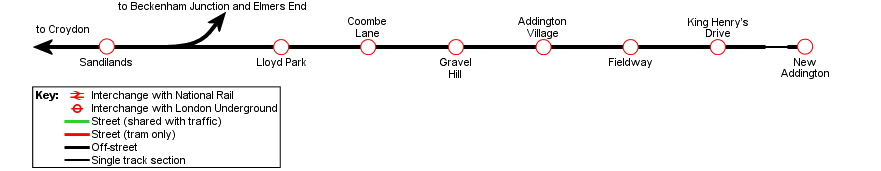
Tramlink's New Addington route runs through the Addington Hills to New Addington, a large postwar housing estate on the outskirts of Croydon. A short section, between Sandilands and Lloyd Park stops, uses a former railway alignment (part of the former Elmers End–Selsdon line), and the rest of the route runs along reserved track on alignments built for Tramlink. Apart from a short section of single track outside the New Addington terminus, the route is double track throughout.
The line through Croydon town centre and from East Croydon to Sandilands is described in the Croydon town centre page.
[select a stop for pictures]
Sandilands–Lloyd Park


From Sandilands the line crosses Woodbury Close and ramps down to reach the alignment of the former Elmers End–Selsdon railway. At Sandilands Junction, Elmers End and Beckenham Junction trams turn left onto the alignment, while trams bound for New Addington turn right to head south. Almost immediately the line enters a tunnel—this is Woodside Tunnel, the first of three tunnels seperated by vent shafts which are refered to collectively as the Sandilands tunnels. The second and third tunnels are Park Hill Tunnel and Coombe Road Tunnel. The combined length of the three tunnels is 560yds (512m).
After emerging from the southern end of these tunnels, the line crosses Larcombe Close to reach the site of Coombe Road station, closed in 1983 along with the railway. The tramway then leaves the railway alignement, veering sharp left to run alongside Coombe Road to Lloyd Park stop, skirting the edge of the park of the same name.
Lloyd Park–Addington Village


From Lloyd Park the line starts to climb as it continues alongside Coombe Road, gaining height to reach Coombe Lane stop. The line here runs through woods—this is the Addington Hills, an area of woodland and open space overlooking Croydon. From Coombe Lane, the line runs past a water tower to reach the summit, crosses Coombe Road by level crossing, then drops down through open fields next to the road, now called Gravel Hill. There is a stop halfway down, called Gravel Hill, after which another level crossing takes the tramway back across the road, by now a dual carriageway.


At the bottom of the hill is a roundabout, alongside which trams turn left before crossing Kent Gate Way at a level crossing. By another roundabout the tram line veers right to a stop at Addington Village transport interchange. Here there is a small bus station next to the tram stop, served by Tramlink feeder buses as well as other local routes.
Addington Village–New Addington

On leaving New Addington, the tramway climbs gently, running alongside Lodge Lane towards the New Addington estate, with an intermediate stops at Fieldway. At the junction with King Henry's Drive, the line crosses the centre of a roundabout and runs in the central reservation of Parkway. King Henry's Drive stop is a short way past this roundabout.
The New Addington terminus is at the end of Parkway, at the end of a short stretch of single track. The stop is close to New Addington's main shopping and amenity area—as well as local shops there is a health centre, library and swimming pool here.
[copyright statement] [terms & conditions] [trespass & safety policy] [privacy]
TheTrams.co.uk is not associated with any transport operator or authority
All content © Peter Courtenay 2004–2026 except where otherwise stated


Page generated in ≈ 0.0026 seconds