Tyne and Wear Metro : Stations : Bank Foot
| Line | Location | Opening date | number of platforms |
|---|---|---|---|
| Green | surface | 10th May 1981 | 2 |
Bank Foot was the original terminus of the line which now continues to the Airport. As originally opened, the station feature a single track and platform, with the other track through the station sued by British Rail freight trains which continued to ICI Callington. After this traffic ceased, the Metro was extended to serve Newcastle Airport, and a second Metro platform was added.
Pictures
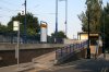
Westbound (Airport) platform at Bank Foot station, showing the ticket machine area
05/07/2006 • 002896
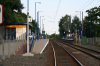
Looking east towards the city at Bank Foot station. This photo was taken from a level crossing
05/07/2006 • 002897
Search for more pictures taken at Bank Foot
Location
Street map
System map
More map links
- Maps of Bank Foot stop on Streetmap:
- View maps or satellite imagery at Google Maps
-
Download a Google Earth KML file
Open in Google Earth or download and install Google Earth Pro
Services and diagram
Services from this stop:
[copyright statement] [terms & conditions] [trespass & safety policy] [privacy]
TheTrams.co.uk is not associated with any transport operator or authority
All content © Peter Courtenay 2004–2026 except where otherwise stated


Page generated in ≈ 0.0200 seconds