Tyne and Wear Metro : Stations : University
| Line | Location | Opening date | number of platforms |
|---|---|---|---|
| Green | surface | 31st March 2002 | 2 |
University station is on the Sunderland extension, serving a residential area as well as the University Of Sunderland.
Pictures
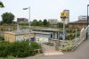
Overall view of University station. On the right is the footbridge
06/07/2006 • 003059
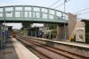
University station platforms, looking towards South Hylton
06/07/2006 • 003060
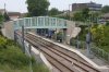
University station, looking towards South Hylton, as seen from the New Durham Road (A690) overbridge
06/07/2006 • 003061
Search for more pictures taken at University
Location
Street map
System map
More map links
- Maps of University stop on Streetmap:
- View maps or satellite imagery at Google Maps
-
Download a Google Earth KML file
Open in Google Earth or download and install Google Earth Pro
Services and diagram
Services from this stop:
Airport via Newcastle
South Hylton
[copyright statement] [terms & conditions] [trespass & safety policy] [privacy]
TheTrams.co.uk is not associated with any transport operator or authority
All content © Peter Courtenay 2004–2026 except where otherwise stated


Page generated in ≈ 0.0210 seconds