Tyne and Wear Metro : Stations : Four Lane Ends
| Line | Location | Opening date | number of platforms |
|---|---|---|---|
| Yellow | surface | 11th August 1980 | 2 |
Four Lane Ends station is part of a major local transport interchange which also includes a bus station. The platforms are underneath the interchange building. The station is on the northern half of the Tyne Coast loop and is close to large government department offices.
Pictures

Four Lane Ends Interchange. The entrance to the Metro station is within
05/07/2006 • 002944

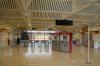
Inside Four Lane Ends Interchange. The entrance to the Metro station is on the left
05/07/2006 • 002945
Ticketing are and concourse at Four Lane Ends
05/07/2006 • 002946

Four Lane Ends at platform level
05/07/2006 • 002947
Search for more pictures taken at Four Lane Ends
Location
Street map
System map
More map links
- Maps of Four Lane Ends stop on Streetmap:
- View maps or satellite imagery at Google Maps
-
Download a Google Earth KML file
Open in Google Earth or download and install Google Earth Pro
Services and diagram
Services from this stop:
| Yellow Line | St James via the Coast South Shields via Newcastle |
[copyright statement] [terms & conditions] [trespass & safety policy] [privacy]
TheTrams.co.uk is not associated with any transport operator or authority
All content © Peter Courtenay 2004–2026 except where otherwise stated


Page generated in ≈ 0.0158 seconds