Tyne and Wear Metro : Stations : Ilford Road
| Line | Location | Opening date | number of platforms |
|---|---|---|---|
| Green/Yellow | surface | 11th August 1980 | 2 |
Ilford Road station was constructed for the Metro. It consists of two separate platforms; the route between them is via a public road bridge over the line a short distance to the south.
Pictures
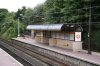
Southbound platform at Ilford Road
07/08/2005 • 002968
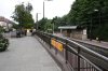
Ilford Road station looking north, with the entrance from Ilford Road to the northbound platform, showing how accessible the platforms are
07/08/2005 • 002969
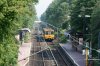
Overall view of Ilford Road. In the distance is the distinctive red footbridge of South Gosforth station
05/07/2006 • 002970
Search for more pictures taken at Ilford Road
Location
Street map
System map
More map links
- Maps of Ilford Road stop on Streetmap:
- View maps or satellite imagery at Google Maps
-
Download a Google Earth KML file
Open in Google Earth or download and install Google Earth Pro
Services and diagram
Services from this stop:
also peak hour short workings to Regent Centre/Monkseaton and to Pelaw via Newcastle
[copyright statement] [terms & conditions] [trespass & safety policy] [privacy]
TheTrams.co.uk is not associated with any transport operator or authority
All content © Peter Courtenay 2004–2026 except where otherwise stated


Page generated in ≈ 0.0131 seconds